PSRMOV Software.jpg)
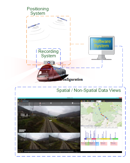
PSRMOV ™ solution is a combined hardware/software system to provide various railway or road data visualizations. This system is developed to produce and maintain multiple site data, like media data (video), spatial data and non‐spatial data,.
This system is developed to capture and maintain multiple site data, like media data (video), spatial data and non-spatial data, in order to:
PSRMOV Elements:
Positioning system:
Online single positioning or real-time kinematic (RTK) GPS sattelite reciever system to provide precise spatial data of routes.
Media recording unit:
Up to 6 wide FHD/HD cameras providing multiple views in several optional directions. High frame-rate (up to 120fps) is supported.
Synchronization software system:
A software system to synchronize GPS and video data recording which supports long-range video recordings. Also, this system supports image-processing operations to extract additional geometric data.
Output user interface:
A software system to maintain and visualize gathered multiple data types (media/spatial /non-spatial).

Capabilities and Key Features:
This system is developed to capture and maintain multiple site data, like media data (video), spatial data and non-spatial data, in order to:
- Capture, process and view video and other spatial / non-spatial precise data synchronously.
- Provide the possibility of data acquisition and process at office.
- Make less site-visiting operations.
- Make decrease in time and environmental pollutions.
PSRMOV Elements:
Positioning system:
Online single positioning or real-time kinematic (RTK) GPS sattelite reciever system to provide precise spatial data of routes.
Media recording unit:
Up to 6 wide FHD/HD cameras providing multiple views in several optional directions. High frame-rate (up to 120fps) is supported.
Synchronization software system:
A software system to synchronize GPS and video data recording which supports long-range video recordings. Also, this system supports image-processing operations to extract additional geometric data.
Output user interface:
A software system to maintain and visualize gathered multiple data types (media/spatial /non-spatial).

Capabilities and Key Features:
- Long‐range data recordings (based on computer hardware system).
- Up to 360⁰ coverage view angle.
- Geo‐tagging on movie/map views.
- Object and description tagging on movie and map
- Meteorological conditions data capture/view (environment temp., wind speed, etc.).
- Special zones view (Earthquake zones, speed limitation zones, tunnels, etc.).
- Plan and longitudinal profile view.
- Additional design document attachments.
- Compatible outputs with AutoCAD, Google earth, etc.
- Dynamic project progress data view.
- Extendable to any vehicle (Railway vehicles, road vehicles, boats, model planes, etc.).
- Slow‐motion recording (up to 120 frame per second).
- High quality output (4K, FHD, HD qualities).
- High quality digital zoom (up to 4x).
- High quality photo capture on movies.